The Big Stuff
⛺ Tent
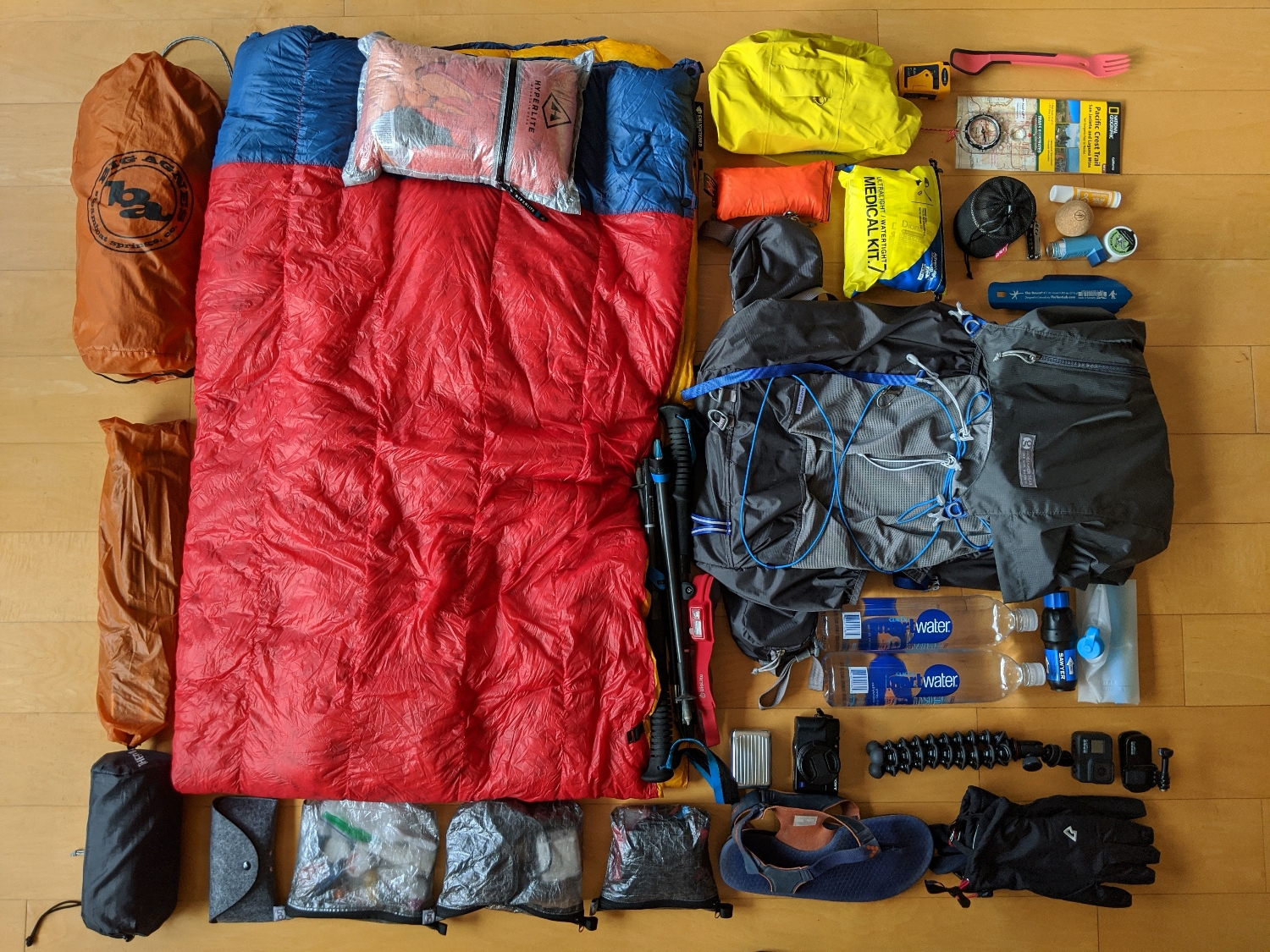
There was a spreadsheet involved in the purchase of this tent. Ultimately wanted a free standing tent rather than a trekking pole tent and with two of us, a door either side is important. We have the Big Agnes Copper Spur UL2 (an older version than this latest, think ours is the 2018 version) and have been very happy with it on a few trips. Sure it’s not the lightest but it’s light enough, withstands storms and keeps bears out (maybe).
? Sleeping Quilt
Yup, a quilt, not a ‘bag’. I find I get hot and sticky in a bag so tried a quilt instead and it’s great! I have the Enlightened Equipment Revelation Quilt 20°F with 850 down fill, 6’6″ (long) Length and 58″ (wide) width. It is quite literally a revelation and even Katie was a converted. She has the same but rated to 10°F.
? Sleeping Mattress
The Thermarest NeoAir XLite is great, warm enough for me in most conditions and comfy enough. Of course there is the risk with a mattress that it gets a puncture but having tried the Thermarest Z Lite mattress, the xlite is so much better (the Z mattress eventually resulted in silver bits everywhere!)
? Bag
After some research, I had decided on the Gossamer Gear Mariposa 60L for backing trips in general and it’s first outing was the Hebridean Way in May 2019 where it performed admirably and so it will be joining me for the PCT. Great accessible outer pockets and able to attach camera case and a Bottle Rocket to the shoulder straps.
? Fanny Pack
ThruPack Summit Bum to keep handy items available.
Footwear
? Shoes
Initially I thought I would stock up on one style of shoe to keep me going through the hike (on average, hikers get through 5 pairs). In the end I’ve resisted doing that completely because some sections might call for different shoe styles, as you hike your feet tend to go up a size and different sections/times of year may call for different sock thickness.
I’m planning on starting in a new pair of New Balance Fresh Foam Hierro v5 in a generous size 11 (I’m a size 9 in normal shoes, wear size 10 normally for running shoes). These have good cushioning and breathability for the desert. They also have room for foot size increase and larger socks without being too big in the first place. I’ve had good experiences with New Balance trail shoes in the past so am confident they will be great! I also have a pair of La Sportiva Mutants in a size up from what I normally wear. I’ve worn these shoes for the past few years for hiking and trail running and the grip on phenomenal so I think they may be a good choice for the High Sierras section where we will see snow and cross lots of rivers.
I’ll decide on others shoes as they are needed based on experiences so far. The most popular shoe choice on the trail (based on survey link) are the X. I did try these out in the Outer Hebrides in May 2019 and did not find them a good option for me.
I’ll decide on others shoes as they are needed based on experiences so far. The most popular shoe choice on the trail (based on survey link) are the X. I did try these out in the Outer Hebrides in May 2019 and did not find them a good option for me.
?Socks
General approach, which I got from Andrew Skurka (link post) is to have a couple of hiking pairs on the go and cycle them each day, washing them if possible and drying when you stop or hang from your pack as you hike. I’ve found this is a good system, it always feels nice to put a ‘fresh’ pair of socks on half way through the day and if you can wash them, it helps the stinky situation (my feet tend to get pretty nasty smelling! ?)
I’ve done long distance running for a few years and always used injinji socks which I’ve found to be excellent at preventing blisters. I think I would benefit from a bit more cushioning than injinji socks provide so I’m going to start the trail with two different options;
- Injini hiking liner sock paired with Darn Tough or Stance Socks
- Injinji hiking sock (most cushioned available)
?♂️ ‘On The Move’
Base
- Shorts : Patagonia Pro Strider 5 inch shorts – comfy, lightweight, great pockets
- Top : Patagonia long sleeved capilene base layer – cool, SPF top coverage
? Layers
- Top : REI Co-op Midweight Base Layer Zip Hoodie
- Trousers: La Sportiva – stretchy, great pockets, really comfy.
? Accessories
- Hat: Ciele GOCap
- Glasses: Vallon Heron Mountain 2.0
- Trekking Poles : Black Diamond Distance Carbon Z
? Stop/Camp Clothing
- Down Jacket: Mountain Equipment Skyline in eye catching bright orange!
- Merino boxers – warm temp sleeping
- Merino leggings – cold temp sleeping
- Camp Footwear: Vivobarefoot sandals for around camp, give my shoes a chance to dry out and my feet a chance to breath
☔ Waterproof Gear
- Jacket: REI Drypoint GTX Jacket. Gets great reviews and I’m happy to carry some weight and pay a bit more for a jacket that will do a good job of keeping me dry.
- Bottoms: ULA Rain Kilt – yeh a ‘skirt’! I find I overheat in waterproof trousers so gonna give a rain skirt a go. Doubles as modesty protection whilst I’m washing all my other clothes in town from time to time!
?Navigation
I’ve no doubt there will be many on the PCT this year with only their phone for route checking and navigation. I believe you need a backup and that good old paper maps are superior in many ways to electronic maps, including giving a much larger view area at one time. So we will have both options;
- NatGeo PCT maps
- Suunto M3 NH compass
- Gaia GPS (which includes the Nat Geo maps electronically)
- Guthook app for trail and town info
- Garmin Fenix 6 (with route loaded on)
?Electronics
I want to capture memories and document the trip through photos and diaries so I have quite a bit of electronic gear. I can always dump some of it if i’m not using it all.
- Go Pro Hero 8 Black – action shots and nice wide view, easy to get pics of Katie and I together
- Sony RX100 IV – takes great photos, has zoom and can add filters
- Google Pixel 2 – does take good pics but using mostly for trip diary, nav backup etc.
- Zendure SuperMini 10000mAh power bank
- Sandisk Extreme Rugged 1TB backup drive
- BioLite HeadLamp 330
- Accessories: Wall charger, cables, 3 batteries per camera, camera battery chargers, spare SD cards, Joby Gorilla tripod with GoPro adaptor.
?Camp Kitchen
- Stove: SOTO Windmaster
- Cookpot: Titanium 1200ml cookpot
- Mug: Alpkit Titanium 400ml
- Utensil: Morsel Spork
? First Aid Kit!
Lightweight Adventure Medical Kit, because it’s good to be prepared
All The Gear…

Lighterpack Breakdown
Yup, I totally geeked out and weighed a load of stuff. ? It’s not uncommon.
https://lighterpack.com/e/w9r5bd


