Day 36: Greenhead to Alston
? 30.54km
?848m
We were looking forward to a relatively easy day, expecting about 26km and 600m ascent. Not sure where the extra came from, and the conditions underfoot were not easy although at least mostly dry. There were also a lot of gates and stiles as we passed through a lot of sheep grazing farmland. All this contributed to a longer day than expected and we both felt it psychologically and physically.

We couldn’t really complain as we passed a few more participants of The Spine Race who were mostly very chatty and happy to stop for a minute or two to ask what we were up to. One lady had had 20 mins sleep on the first and second nights, and had been seeing dinosaurs eating houses amongst other hallucinations! ??
In what was a fairly boring day, one of the highlights witnessing a couple of rams getting in a bit of mating season practice on each other.

We had booked a hotel in Alston a couple of weeks back so we were really looking forward to getting there early afternoon, which didn’t happen. Upon reaching Alston we played bull in a China shop, squeezing through narrow aisles of the Co-Op, grabbed a gas canister from the outdoor store and then made our way to our hotel, the Lowbyer Manor Country House. It was a lovely hotel, really old school and quirky, in a brilliant way. I showered and then put my feet up whilst destroying a tub of Ben & Jerry’s and a Punk IPA.

We ate at the Cumberland Inn, both had Cumberland Sausage, and then I had a STP – the sponge was good, nothing special, but the sauce was great plus custard AND ice cream, all added together to make a damn good STP! The Pennine Pale Ale was good too!
Day 37: Alston to Dufton
? 33.17km
?1057m
I’d completely forgotten before we arrived yesterday that our hotel included breakfast! We had planned an early start with a long day ahead, so we were first to breakfast at 0800. We helped ourselves to cereals, yoghurt, juice, then I had a full cooked breakfast and Katie had scrambled eggs and smoked salmon. We left rather full and we’re grateful that the first ascent of the day didn’t start right away!
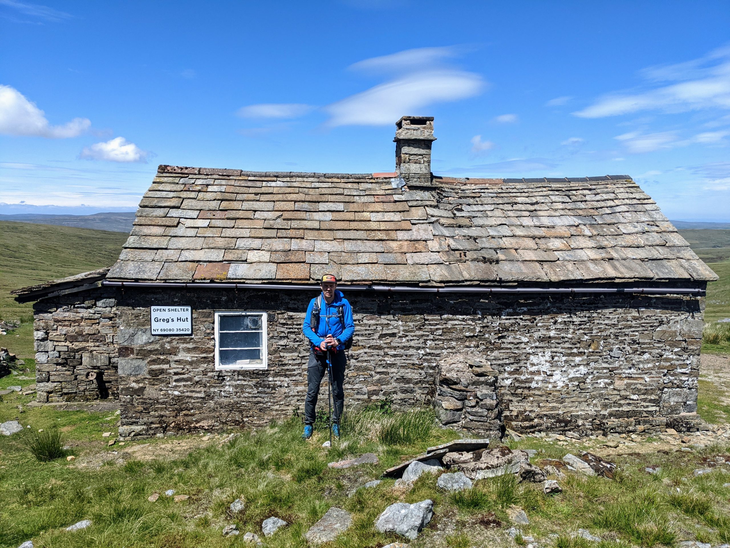
To start off we were walking along a river to Garrygill village, very pretty little place. The ascent really started from there, gradually climbing along a decent track up to an old mining area where the track continued but was rockier. We reached Greg’s Hut, an MBA bothy, and sat outside to eat our lunch. Before moving on we checked out the bothy, wrote in the log book, and chatted to a father a son doing the PW in 10 days. They commented that another son/brother had started with them but quit after 3 days. I got the feeling he wouldn’t be hearing the end of that! ?


The cloud had covered the tops first thing and had been lifting through morning. By the time we reached the top of Cross Fell (the highest point of the End to End Trail – we lied previously in a post from Scotland, that was the highest pass on the trail, not the highest point!) it was a glorious day and we were treated to views of the Lake District and the Yorkshire Dales. We spent some time drinking in the views and getting the obligatory trig point selfie before we crossed the Moreland on Cross Fell and had a series of up hill, down dale, taking in Little Dun Fell, Great Dun Fell and Knock Old Man.


The descent to Dufton was quite steep in places, reaching farmland and tracks in to Dufton. It had started raining as we were closing in on the village and we put up tent in the rain and cooked dinner.
The rain didn’t ruin what was a great day, our second biggest so far in terms of ascent, the highest point on the trail, and some epic scenery.

Day 38: Dufton to Kirkby Stephen
? 28.02 km
?469m
It rained pretty much all night and was still raining in the morning. The wind had also really picked up in the night. Thankfully the campsite was quite sheltered but the wind had blown all sorts of tree debris everywhere by the morning. Checking the weather, it was due to rain all day and the mountain weather forecast suggested the cloud would cover the tops until the afternoon at least.
Our route today was described by the guidebook as one of the best days of the trail and definitely the best of the Pennine Way. It would take us past High Cup Nick, which looks pretty cool, and to a height of around 600m. After taking the cloud cover, wind, rain, and the fact we had no paper maps for this section, we decided to take an alternative route and instead stop in Kirby Stephen tonight, then rejoin our End To End route at Keld tomorrow evening. It also would mean two slightly shorter days than we had planned, which would hopefully help on the blister front.

We were conveniently able to follow another marked trail, The Pennine Journey, which was mostly easy to follow and took a lower level route through farmland and along the River Eden. It wasn’t a bad route and although it rained all day, it was only of the significantly wet variety for an hour or so. The highlights were probably some vivid green meadows and fields, offset against the dark grey moody clouds. That and a couple of squeaky bum moments passing through small fields full of rams who seemed rather interested in us, grunted a lot and followed us looking aggressive. We’ve passed other groups of rams on the trip who didn’t appear as interested/grumpy.

Towards the end of the route, the Pennine Journey took a bit of a circuitous route and we opted for a few km of quiet B road as we were rather damp. We stopped off at Co-op and stocked up on food, then continued through town to our campsite. Unfortunately the washing machine was broken so we hand washed some socks and hung up damp clothes to dry. After a shower we found a nice comfy sofa in The Engine Shed, the on site bar.
We checked out a route for tomorrow and did a DIY link up of trails using the OS app to get an 18km off road route to Keld. It was this or about 15km on a minor B road. The weather is looking like it will clear up nicely so should be a no brainer!
We had a pizza from the pop up pizza van at the campsite and ate that with our other supplies for dinner in the bar whilst we caught up on some journals and other things. It turns out that Kirby Stephen is on the Coast to Coast trail route so you never know, might be back here sometime!

Leave a Reply